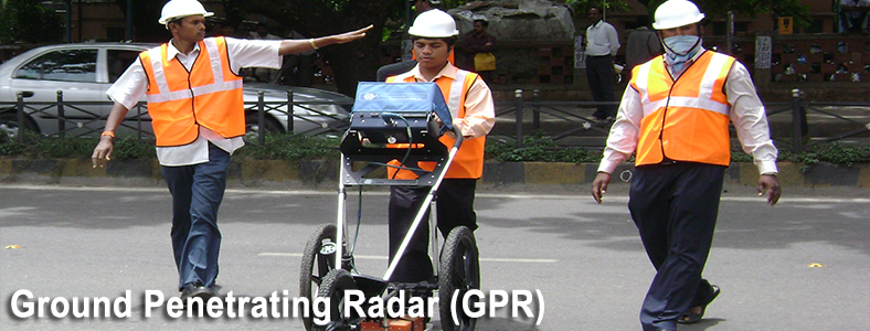
Have you ever wondered how underground structures can be located and analysed with the most up-to-date technology? Ground Penetrating Radar (GPR) scanning, also known as Subsurface Utility Engineering (SUE), is a unique, non-destructive tool used to detect objects or anomalies buried beneath the ground’s surface. Whether it’s locating pipes and sewers, looking for sinkholes/weaknesses in roadways and bridges, or even finding unmarked gravesites— GPR scanning uses electromagnetic radiation pulses that penetrate into the ground and allow for safer, smarter solutions when mapping out data of what lies beneath. This type of scanning helps engineers save time on site visits while reducing potential safety risks due to not having to physically break open surfaces. Learn more about this groundbreaking technology in this blog post!
What Is Ground Penetrating Radar (GPR) And How Does It Work?
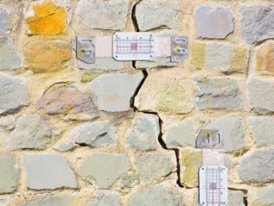
Ground Penetrating Radar (GPR) scanning is a powerful non-invasive technique used to assess the internal properties of materials, structures, and the ground beneath them. It uses radar pulses to penetrate the surface and bounce back off underground objects to generate an image of what lies beneath. By analysing the data collected from GPR scans, engineers can identify objects such as pipes and cables, determine their location concerning one another and measure the depth at which they lie. GPR also has applications in geotechnical engineering where it can be used to detect fractures or voids that may have resulted from subsurface instability. GPR works by emitting electromagnetic pulses into a material or structure, which then reflect off of objects within it and return to a receiver antenna attached to an electronic device. The time taken for the pulse to travel from transmitter to receiver is measured and combined with factors such as frequency and antenna configuration, enabling detailed images of underground structures and objects to be generated.
How Accurate Is GPR Scanning/Ground Penetrating Radar?
Ground Penetrating Radar (GPR) Scanning is a geophysical technology that can accurately identify and map subsurface features in the ground. GPR scanning gold coast is an invaluable tool for surveying engineers and archaeologists, as it allows them to create detailed images of underground objects without having to dig or take samples. What’s more, this type of scanning is extremely accurate and reliable; in fact, its accuracy has been measured at just a few centimetres when using suitable equipment and in the right conditions. Its accuracy is further enhanced by combining it with other types of imaging technologies such as GPS or sonar, enabling it to accurately locate buried objects even from hundreds or thousands of meters away. GPR scanning also has the advantage of being able to penetrate through nearly all types of soil or urban material, meaning it’s possible to detect both man-made and natural structures beneath the surface without any interference from above-ground obstacles. Its use ranges from locating underground utilities in civil engineering projects to detecting antiquities in archaeological surveys—demonstrating its versatility as a powerful survey tool.
Is GPR Scanning/Ground Penetrating Radar Better Than X-ray?
Ground Penetrating Radar (GPR) Scanning is a revolutionary non-destructive testing technology that offers numerous advantages over traditional X-ray methods. While both X-ray and GPR can detect subsurface anomalies, the latter provides far greater subsurface detail, penetrates deeper into the ground, and can detect objects in real-time at much greater depths than could be accomplished with X-ray. Additionally, GPR scanning does not require radiation or any other potentially hazardous substances to complete the task successfully. This makes it a much safer option for detecting buried items and structures than X-rays.
Where GPR Scanning/Ground Penetrating Radar Is Commonly Used
Ground Penetrating Radar (GPR) is a powerful tool used in many different industries and applications. It is most commonly used to detect underground utilities such as pipes, cables, and drainage systems. In addition, GPR scanning is widely utilised in archaeological surveys to locate buried structures like foundations and walls. Additionally, GPR can be used to locate buried evidence at crime scenes or locate victims that have been lost or buried in natural disasters. Furthermore, GPR can be employed to inspect the integrity of concrete structures like bridges and highways by detecting signs of deterioration or cracks beneath the surface. Lastly, GPR provides invaluable information for geotechnical engineers by providing a glimpse into what’s below the soil so they can properly construct buildings and other structures without jeopardising safety or stability. As technology continues to advance, GPR scanning will become an even more reliable tool for use across a myriad of fields and applications.
The Benefits Of Using GPR Scanning/Ground Penetrating Radar
Ground Penetrating Radar (GPR) scanning is an invaluable tool for many industries. This type of radar relies on radio waves to send and retrieve information about underground features and can be used in a variety of applications such as archeological site mapping, utility locating, road surveying, and diagnosing concrete structures.
Using GPR scanning results in many benefits such as increased safety; it eliminates the need for invasive methods while providing accurate data that is not possible with manual inspection. In addition, this type of scanning can save time by quickly detecting problems below the surface before they become costly repairs. GPR scans also provide detailed images that are much clearer than traditional methods, making it easier to identify structural problems or underground objects. Finally, because GPR scans are non-destructive, there is no damage to the surface or excavation needed.
Conclusion
It is clear that GPR scanning technology offers many benefits and opportunities for a variety of applications. From locating objects to analysing material compositions, ground-penetrating radar scans can be utilised to help uncover information that would otherwise be hidden underground. While this technology still has room to develop, it is making leaps and bounds in discovering groundbreaking insights within the earth’s surface. With the right team and resources, GPR scanning can aid any project with successful results. Whether it is exploring an archaeological site or finding underground utilities, ground-penetrating radar has no doubt become an invaluable tool in the world of geophysics today. For all your GPR scanning needs, contact the pros at South East Scanning!